Company -> Partners
ESRI
Symology is an ESRI International Business Partner (UK New Business Partner of the Year 2008)

Ranked by Software Magazine as one of the 50 largest software companies in the world, ESRI is considered one of the most innovative companies in the software business.
Founded in 1969, ESRI's GIS solutions are emerging as an integral component in nearly every type of business and government service. Headquartered in Redlands, California, ESRI has offices throughout the United States; a Business Partner Program with more than 1,000 developers, consultants, resellers, and data providers; and a network of international distributors onducting business in more than 189 countries.
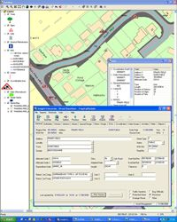
Symology's Insight provides comprehensive mapping functionality by utilising the latest technologies to interface seamlessly with ESRI's ArcGIS range. This provides users with synchronised bi-directional connectivity, full enquiry and updating capabilities, as well as the ability to "drive" the system from the Map.
The embedded functions exploit the capabilities of the ArcGIS desktop mapping products, including sophisticated symbology definition, layer control and the ability to read and display all supported GIS, CAD and graphic formats, as well as being able to utilise Web Mapping & Web Feature Services.
The Insight system allows Multiple Map Definitions to be defined and allocated to users, allowing different users to access the embedded mapping with personally tailored views.
Functionally, the facilities include:

- A suite of National Street Gazetteer Maintenance tools, which include the ability to utilise Ordnance Surveys MasterMap ITN later and also maintain Associated Street Data such as Traffic Sensitivity and Reinstatement Category information.
- Network Maintenance facilities for Pavement Management Engineers allow multiple linear referencing systems to be defined and managed spatially including the identification of section directions and routes. These new facilities also enable processed condition survey results such as recommended treatments and condition indices to be automatically displayed on the map, making full use of ESRI's dynamic segmentation facilities.
- Street Works records can be automatically plotted on the map. Full co-ordination checks are available, to pinpoint conflicting works in the same street, within user defined proximities or on diversion routes. Pinch-points, particularly significant for traffic disruption at busy junctions, can also be defined. Once plotted, Insight will add the area to the co-ordination checks and raise warnings for any works that are plotted in the area.
- Facilities are also provided to plot/edit/delete Customer Service Requests, Works Orders, Licence Requests and any Asset held in the Insight system such as Street Lights, Traffic Signals, Bridges/Structures, Grass verges etc.


