Symology has created Aurora to bring together over 40 years of sector experience with the latest technology, delivering powerful yet easy to use Asset Management features, tailored to work exactly as you need.
Our out-of-the-box solutions cover Highways, Street Lighting, Drainage and Flood Risk, Bridges & Structures, Arboriculture and much more, giving you features to manage and maintain your infrastructure.
Network Management
All organisations have a responsibility to manage the assets that they own, which includes the management of a comprehensive inventory. Aurora uses standard, out-of-the-box asset types offering a best practice approach to asset management. Covering highways, street lighting, drainage, street furniture, structures, traffic signals, public rights of way, land and property, flood risk and green assets, asset definitions are designed in line with all relevant Codes of Practice, including the Well-managed Highway Infrastructure Code of Practice.
Integration with corporate systems and web pages forms a key part of a full end-to-end solution. Interface requirements with CRM, finance, GIS and contractor solutions are commonplace in addition to public facing web portals and smart city sensors, all of which are accommodated for use with Aurora. Integration with national Street Works systems also forms part of the standard APIs available for operation with Aurora.
Any level of defect lifecycle is accommodated using the out-of-the-box defect types, with customising facilities to encompass local processes. Whether there is a requirement for extra fields at defined points, additional stages in a lifecycle or sign-off procedures, Aurora integrates local processes into the standard features.
Aurora facilitates contractor operations for different organisational structures, be it internal or external contractors or a combination of both. Seamless transmission of works from the client to the contractor, including associated material and timescales, offers the full lifecycle of a works from inception to completion.
Financial management through Financial Years and Financial Codes provides an integrated facility for organisations to monitor spend across all areas of operation from reactive works to capital schemes.
Lifecycle planning and selection of works for capital schemes are integral to the ongoing maintenance of an organisation’s network. Facilities for the management of identified potential schemes from a tranche 3 accredited function alongside displaying proposed schemes spatially are all available as part of the solution. Upon confirmation of the planned schemes, full scheme management tools support the progression of the maintenance job from inception to completion.
Whilst Aurora accommodates the management of a vast range of asset types, in some solution areas, legislative obligations and best practice processes must be catered for. This includes but is not limited to, GN22 and Unmetered Supply Extract for Street Lighting and Structures Condition Indicators and Structures Asset Valuation Investment (SAVI) Tool for Bridges and Structures.
Good communication with residents and members of the public increases satisfaction, which includes opportunity to raise defects in a quick and simple manner. Aurora provides tools for members of the public to report issues online with seamless integration to progress the reports based on internal rules. In addition to simplified reporting in the first instance, automated communication with the customer provides updates at defined frequencies in addition to self-serve opportunity.
Compliance Monitoring
 With works occupying a Local Authority’s network, it is important that they operate in line with legislation and Codes of Practice. The monitoring of this compliance is streamlined through extensive facilities built into Aurora.
- Inspection sampling directly from Street Manager
- Simplified monitoring of inspection progression and performance
- Visibility of banding and category quotas
Aurora’s inspection management facilities are comprehensive, enabling receipt of sampled inspections for Street Manager, details of category quotas and tools for monitoring performance.
All prompted statutory inspections are sampled within Street Manager and downloaded to Aurora for completion via the Aurora app. Aurora’s associated app facilitates the recording of both prompted and adhoc inspections alongside the ability to view previously recorded inspections and the associated result from site, with automated triggering of a follow up inspection, where applicable. The addition of photographic evidence to inspection results assists with faster acceptance of defects leading to quicker resolution.
An out-of-the-box Inspection Dashboard includes widgets to monitor progress and performance for each of the statutory inspection categories, in addition to the number of inspections accepted and declined, including Section 81 responses. Additionally, all inspection statistics are collated in a single, easy view for visibility of all inspection progress and Promoter performance. Furthermore, due inspections are clearly displayed in due date categories to ensure that progression is made to record the correct number of inspections in each quarter.
- Overrun reporting tools for simple monitoring and progression
- Automated calculation of charges, including mitigated, using centrally maintained fee matrix
- Clear status on a per works basis for individual management
The issuing and management of Section 74 Overruns is simplified within Aurora through inspection recording, automated calculation of charges and subsequent overrun process with the Promoter.
Potential overrunning works are identified via the app dashboard for inspectors to visit, with facilities to record Site Occupancy Monitoring (SOM) inspections. With all SOM inspection results available, in addition to comments and attachments, the Aurora app streamlines the initiation of the Section 74 process.
Standard, inbuilt reporting functionality facilitates the issuing of an overrun warning, followed by subsequent management. With separate Overrun and Overrun Charges enquiries, the associated lifecycles are easily navigated, enabling reporting on all Overrun statuses.
Further simplifying the identification of an issued Overrun, a standalone Overrun section for each works displays the latest status from both the Authority and the Promoter. A direct link provides quick access to the offence itself and subsequent charges. Utilising a standardised, national fee matrix, the charge is automatically calculated based on the chosen end date and defined location.
- Automatic prompting of Fixed Penalty Notices in line with legislation and Code of Practice
- Management of full end-to-end lifecycle, including mobile use
- Reporting tools for performance monitoring
Works Promoters have legal responsibilities with regards to their works and the associated processes, against which Local Authorities are required to ensure compliance. In-built Fixed Penalty Notice management tools simplify the identification of noticing and compliance failures and the processes which follow.
Comprehensive validation rules are used to notify users should noticing rules in line with legislation and Codes of Practice be triggered. Whilst legislation is fixed, Aurora’s flexibility allows organisations to set which validation messages will prompt Fixed Penalty Notices for review. This automatic creation of Fixed Penalty Notices significantly reduces the time required to identify noticing failures. Following the automated prompting, individual or bulk issuing tools simplify the distribution of penalties to the appropriate Works Promoters.
Following issue, standard enquiry reporting and dashboard widgets facilitate the monitoring of Fixed Penalty Notice responses, which can also be used from a performance monitoring perspective to drive operational improvements.
- Centralised Charge list for all Street Works charges
- Automatic prompting of charges
- Bulk issue and payment recording facilities
A centralised charge list within Aurora covers all Street Works charges, including nationwide permit fees, inspections, overstay and Fixed Penalty Notice. Charges are automatically established when triggered by an event, such as the recording of a permit grant or an inspection, utilising the standard charge matrix. Adhoc, manual charges are also accommodated when required.
Adjustments are facilitated through the charge screens and time-saving bulk update options, including bulk issue of charges, enable charging to be managed efficiently. Financial reporting is incorporated facilitating reports by charge type and all issued charges, with additional capability to record payment information.
Mobile Operations
Remote operative productivity is achieved through the Aurora app, ensuring when out in the field, inspectors and operatives have access to the necessary information to complete their jobs.
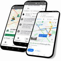 Whether in an area of network connectivity or not, the app continues to operate and synchronisations with Aurora are initiated when signal is available. Inspections, defects, customer reports, street works, licences, assets and jobs are recorded, updated and progressed via the app with dashboards and task lists to assist in planning and routing. Map display, GPS utilisation, navigation via Google Maps and route optimisation tools bring about operational efficiencies to use alongside local knowledge.
Non-Street Works activity inspections, such as licences and events are facilitated via the Aurora app, ensuring monitoring and compliance of other network occupying activities.
- Visibility of due inspections with recording capability
- Facilities to record adhoc inspections
- Attachment of photographs for both external and internal publication
Aurora prompts due statutory inspections based on the Performance Based Inspections sampling process within Street Manager. These are distributed to the appropriate mobile device for completion by an Inspector. Due inspections are highlighted with defined symbology such that GPS location may be used to plan an inspection route by attending the next closest due inspection. Alternatively, a Task List enables manual route planning in addition to utilising the route optimisation facilities to navigate to the works via the most efficient route.
Adhoc inspections are also accommodated, which may consist of nationally defined inspections, or an organisation’s own defined inspections used to supplement those in the Inspections Code of Practice. Photographs taken as evidence of an inspection result are attached and issued alongside the inspection itself.
Web-based ESRI Mapping
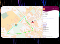 Aurora’s web-based mapping offers users a familiar look and feel with standardised colour coded icons by traffic impact for ease of activity identification. Map-driven operations are facilitated through multi-select options, displaying all eligible entities to the user for selection and action.
Incorporation of Google Street View alongside Street Works and Highways licences data, simplifies the reviewing of works from a coordination and collaboration perspective, in addition to apparatus ownership.
Geographical areas are defined as spatial areas, typically representing an organisation’s operational areas or inspector patches. These spatial areas are used system wide for directing inspections and works to specific users’ mobile app in addition to tailoring views within the dashboard widgets and providing filtering options within enquiries.
Default mapping layers are provided, based on best practice, including streets from the National Street Gazetteer (NSG) and Associated Street Data (ASD), which are updated on a monthly basis using the latest published Gazetteer from GeoPlace. Inclusion of Authority local map layers, such as Highways Extent provide visibility of Authority network ownership when reviewing licence applications.
- True web-based ESRI mapping
- Standardised symbology with colour coded activities by impact and status
- Map layers with toggle capabilities to control view
Aurora’s map centric user interface offers true web-based mapping via ESRI ArcGIS Online. Standardised, colour coded icons provide a view of network occupancy at a glance, including the traffic impact and status. This includes the display of all Promoter works, both Utility and Authority, in addition to Highway licences for a holistic view of the Authority area. Map layer toggle tools facilitate user-determined visibility of the desired map data.
- Visibility of external GIS data such as Highways Extent layers
- Monthly National Street Gazetteer (NSG) and map updates
- Google Street View
Monthly updates of the latest published National Street Gazetteer ensures consistency between Local Authority and Works Promoter systems. Greater accuracy of apparatus identification and street ownership is facilitated through the integration with Google Street View and the inclusion of local map layers within Aurora. Aurora facilitates consumption of local map layers through a regular import of static data or via WFS.
- Pre-defined spatial areas
- Cover ward areas and inspector patches
Pre-defined spatial areas cover all your operational requirements, enabling distinction of geographical areas such as wards or inspector patches with quick and easy navigation between them. Spatial areas offer a user-friendly and simple method to filter information, including the display of activities via the map and determining the geographical search parameters within the enquiries in addition to allocation of inspections to defined inspector patches.
Comprehensive Reporting Tools
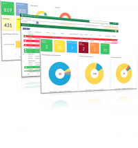
With the vast amounts of data required for Highways Asset Management purposes, having a solution that provides easy and user-friendly access to that data for reporting purposes is imperative. Aurora contains extensive reporting tools for both operational day-to-day and management reporting requirements. Integrated, dynamic dashboards alongside parameterised enquiries fulfils these needs and some. Standard reports for third-party claim defence are incorporated alongside industry standard reports.
- Works lifecycle monitoring tools
- Inspection performance monitoring
Aurora’s dynamic dashboards offer visualisations of all activities and associated actions, ensuring quick identification of the status of the works occupying the network, using time-based categories, to easily monitor works through their lifecycle, ensuring prompt progression and quick identification of overdue actions. Inspection and Fixed Penalty Notice widgets provide immediate visibility of inspection and Fixed Penalty Notice statistics to monitor performance. All widgets have drill-down capabilities immediately taking the user to the detail behind the report.
- User-definable grid reporting
- Saveable views with scheduled export facilities
- Manual exports of data
Aurora’s vast reporting tools cover user-definable grid reporting with parameterised search options and filtering, sorting, grouping and highlighting tools for the results. Once grid views have been designed, save options are available for use time and time again. Export options are available, both manually and via a scheduled process, offering quick and easy access to your data.
- User-defined true spatial plot search options
- Multiple spatial areas facilities
The inbuilt enquiries offer both parameterised search fields and true spatial search tools with facilities for users to plot their own polygon areas to use for their search. Increased flexibility and user control is realised through applying multiple polygons to search criteria on an adhoc basis. Further flexibility is provided via the tabular and spatial export options in addition to a map filter for the results of the enquiry.
- Email notification defined by business triggers
- Notification alerts of pertinent information for users
Aurora enables users to select which alerts they wish to receive via email, which acts as a reminder or notification of defined events. User-configurable on screen notification alerts enable a user to be immediately alerted to an action, allowing them to react quickly.
Aurora Asset Management and Street Works Solutions
Powerful, yet easy to use – Aurora fulfils your every Infrastructure Asset Management requirement.
Our best practice solutions cover Highways, Street Lighting, Drainage and Flood Risk, Bridges & Structures, Arboriculture and much more, each can be further tailored to work exactly as you need.
Local Authorities and other road owning organisations need a best of breed network coordination solution, as well as many features such as mobile working and effective management reporting.
With all this, and native Street Manager integration, Aurora delivers the full package.
With excellent permit and notice management, charge management, mobile working and inspections, integration and reporting features, Aurora will fit perfectly with your way of working.
Our Pay-Per-Works solution provides promoter and contractor organisations operating in England with access to the power of Aurora, with a simple, cost effective pricing model.
This option is suited to those organisations raising fewer permits per annum.